Introduction#
The Open Global Glacier Model (OGGM) is an open source modelling framework for glaciers. It has been developed since 2014: intermittently at first, and more regularly since 2016. Today, OGGM is continuously discussed and updated by a team of international researchers.
Our main aim is to assist the modelling of the evolution of mountains glaciers at the river basin, regional and global scales.
The OGGM framework offers various solutions to the challenges encountered when modelling a large number of glaciers. Here is a non-exhaustive list of its features:
OGGM features
- Data preprocessing
Acquisition, download and processing of a large number of digital elevation models, gridded climate datasets, reference datasets for model calibration and validation such as geodetic mass balance and velocity products, and more…
- Climatic mass balance
Mass balance models of various degrees of complexity, interchangeable, extendable and reprogrammable by anyone.
- Glacier geometry evolution models
Suite of glacier evolution models of different types including toy models, statistical approaches (e.g. volume-area scaling and delta-h parameterization), and explicit approaches (including an ice dynamics module).
- Plug and play
OGGM ships with a large set of pre-processed glacier states that can be downloaded and applied in modeling workflows using only a few lines of code.
- Distributed computing
Automated and seamless task management system for efficient multiprocessing in cluster environments.
- Reproducible and sustainable code
Well tested and well documented codebase, including online tutorials. Regularly maintained and freely available container environments for reproducibility across platforms and HPCs.
- Community
Welcoming community of users and developers: get in touch and join us!
Example workflow#
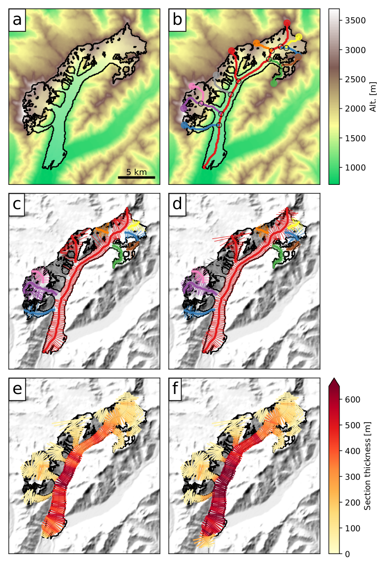
We illustrate with an example how the multiple flowlines OGGM workflow is applied to the Tasman Glacier in New Zealand. Below the figure we describe shortly the purpose of each processing step, while more details are provided in other sections.

- Preprocessing
The glacier outlines are extracted from a reference dataset (RGI) and projected onto a local gridded map of the glacier (Fig. a). Depending on the glacier location, a suitable source for the topographical data is downloaded automatically and interpolated to the local grid. The spatial resolution of the map depends on the size of the glacier.
- Flowlines
The glacier centerlines are computed using a geometrical routing algorithm (Fig. b), then filtered and slightly modified to become glacier “flowlines” with a fixed grid spacing (Fig. c).
- Catchment areas and widths
The geometrical widths along the flowlines are obtained by intersecting the normals at each grid point with the glacier outlines and the tributaries’ catchment areas. Each tributary and the main flowline has a catchment area, which is then used to correct the geometrical widths so that the flowline representation of the glacier is in close accordance with the actual altitude-area distribution of the glacier (Fig. d).
- Climate data and mass balance
Gridded climate data (monthly temperature and precipitation) are interpolated to the glacier location and corrected for altitude at each flowline’s grid point. A carefully calibrated temperature-index model is used to compute the mass balance for any month in the past.
- Ice thickness inversion
Using the mass balance data computed above and relying on mass-conservation considerations, an estimate of the ice flux along each glacier grid point cross-section is computed by making assumptions about the shape of the cross-section (parabolic, rectangular or trapezoid). Using the physics of ice flow and the shallow ice approximation, the model then computes the thickness of the glacier along the flowlines and the total volume of the glacier (Fig. e).
- Glacier evolution
A dynamical flowline model is used to simulate the advance and retreat of the glacier under preselected climate time series. Here (Fig. f), a 120-yrs long random climate sequence leads to a glacier advance.
New in version 1.4!
Since v1.4, OGGM now has another way to compute flowlines via binned elevation bands [Huss_Farinotti_2012]. See Glacier flowlines for more details.
