FAQ and Troubleshooting#
We list here some of the questions we get most often, either on our Slack workspace or on github.
What is the difference between OGGM and other glacier models?#
There are plenty of established ice dynamics models, and some of them are open-source (e.g. PISM, Elmer/Ice, IGM).
The purpose of OGGM is to be an easy to use, fully automated global glacier model, i.e. applicable to any glacier in the world with or without specific tuning or tweaking. Therefore, it does not attempt to replace (and even less compete with) these established ice dynamics models: it can be seen as a “framework”, a set of unified tools that eases the process of working with many mountain glaciers at once.
There is a standard modelling chain in OGGM (with a mass balance model and a flowline model) but there is no obligation to use all of these tools. For example, we can easily picture a workflow where people will use OGGM to create homogenized initial conditions (topography, climate) but use a higher order dynamical model like IGM instead of the simplified OGGM dynamics. For these kind of workflows, we created the OGGM-contrib example package which should help OGGM users to implement their own physics in OGGM.
Can I use OGGM to simulate <my favourite glacier>?#
The short answer is: “yes, but…”
The longer answer is that OGGM has been designed to work with all the world’s glaciers and calibrated as well as we can, but with publicly available global datasets. We are quite confident that OGGM provides reasonable global estimates of glacier mass balance and glacier change: this is a result of the law of large numbers, assuming that the uncertainty for each single glacier can be large but random and Gaussian.
If you use OGGM for a single or a handful of glaciers, chances are that the outcome is disappointing. For these kind of applications, you’ll probably need to re-calibrate OGGM using local data, for example of mass balance or observations of past glacier change.
Can I use OGGM to simulate long-term glacier evolution?#
It depends what you mean by “long-term”: at centennial time scales, probably, yes. At millennial time scales, maybe. At glacial time scales, probably not. The major issue we have to face with OGGM is that it uses a “glacier-centric” approach: it can simulate the mountain glaciers and ice-caps we know from contemporary inventories, but it cannot simulate glaciers which existed before but have disappeared today.
Also, if glaciers grow into large ice complexes and ice caps, the flowline assumption becomes much less valid than for typical valley glaciers found today. For these situations, fully distributed models like IGM or PISM are more appropriate.
In addition, there is some issues about glacier growth: you have to be sure the limit border you have defined is large enough to allow a large growth of glaciers; secondly, you need to authorize the merge of glaciers which is implemented into OGGM but not automated ; last, there might be not negligible changes in the landscape around the glacier as well as evolution of the glacier bed for long-term simulations.
We are currently in the process of testing and tuning OGGM for post-LIA simulations in the Alps. Reach out if you would like to know more about our progress.
I have a question about OGGM, can we talk about it per email/phone?#
Thanks for your interest in OGGM! The best place to ask questions is in our interactive forum, the Slack #support channel so that everybody can learn from all questions and their answers. More information on how to join the Slack can be found on the community website. We also have a community guideline how to best raise your question or find the error in your code. Keep in touch with us if you’d like to join, we are a very open community!
If you are working on OGGM code development or encounter a bug in the codebase, raising an issue on GitHub in one of the OGGM repositories may be more appropriate. For example, on github.com/OGGM/oggm/issues for the main OGGM code.
Can I export OGGM centerlines to a shapefile?#
Yes! There is a function to do exactly that:
utils.write_centerlines_to_shape(). We also provide some already
processed ones in Useful outputs.
Can I export OGGM’s <special variable> to <another programme>?#
Yes! Although it might make you have to write some code. The developers cannot think of all the great ideas/potential applications you have for the model. We also do a lot of work within the OGGM framework, i.e. most of the data we need is already there. Some variables are hidden, see e.g. here and there for discussions on github.
If you need some specific variables, please write on GitHub and we can discuss.
What is the ice dynamics parameter “Glen A” in OGGM?#
Out-of-the box, non-preprocessed OGGM will use fixed values for the creep parameter \(A\) and the sliding parameter \(f_s\):
In [1]: from oggm import cfg

In [2]: cfg.initialize()

In [3]: cfg.PARAMS['glen_a']
Out[3]: 2.4e-24

In [4]: cfg.PARAMS['fs']
Out[4]: 0.0
That is, \(A\) is set to the standard value for temperate ice as given in [Cuffey_Paterson_2010], and sliding is set to zero. While these values are reasonable, they are unlikely to be the ones yielding the best results at the global scale, and even more unlikely at regional or local scales. In particular, in the absence of sliding parameter, it is recommended to set \(A\) to a higher value to compensate for this missing process (effectively making ice “less stiff”).
New in version 1.4!
Since v1.4, OGGM can now calibrate \(A\) based on the consensus from [Farinotti_etal_2019] on any number of glaciers. We recommend to use a large number of glaciers: OGGM’s default glacier directories are calibrated at the RGI region level. This value is then also used by the forward dynamical model for consistency, according to the parameter use_inversion_params_for_run.
The pre-processed directories at level 3 to 5 are already calibrated to the consensus estimate at the RGI region level, i.e. unless specified otherwise, OGGM will use the pre-calibrated \(A\) value for these glaciers.
There is a way to calibrate \(A\) for the ice thickness inversion procedure based on observations of ice thickness (see this blog post about g2ti for an example). At the global scale, a value in the range of [1.1-1.5] times the default value gives volume estimates close to [Farinotti_etal_2019]. At regional scale, these values can differ, with a value closer to a factor 3, for example for the Alps. Note that this depends on other variables as well, such as our estimates of solid precipitation amounts (i.e mass turnover). This makes things complicated, as regions with overestimated solid precipitation can be compensated by a higher \(A\), and the other way around.
Finally, note that a change in \(A\) has a very strong influence for values close to the default value, but this influence reduces to the power of 1/5 for large values of A (in other words, there is a big difference between values of 1 to 1.3 times the default \(A\), but a comparatively small difference for values between 3 to 5 times the default \(A\)). This is best shown by this figure from [Maussion_etal_2019]:
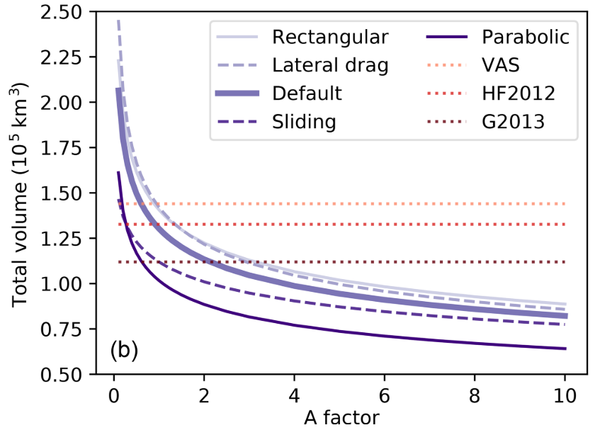
Global volume estimated as a function of the multiplication factor applied to the ice creep parameter A, with five different setups: defaults, with sliding velocity, with lateral drag, and with rectangular and parabolic bed shapes only (instead of the default mixed parabolic/rectangular). In addition, we plotted the estimates from standard volume–area scaling (VAS, \(V = 0.034 S^{1.375}\)), Huss and Farinotti (2012) (HF2012) and Grinsted (2013) (G2013). The latter two estimates are provided for indication only as they are based on a different glacier inventory#
Now, what you are probably asking yourself: how to choose the “best A” for my application?
Sorry, but we don’t know yet. We are working on it though! At the moment,
what we recommend to do is to calibrate \(A\) so that the regional
(or even local) estimates match the volume consensus of
Farinotti et al. (2019)
using the workflow.calibrate_inversion_from_consensus() global
task. This is what we do for the default pre-processed directories at the
RGI region level, so that you don’t have to worry about it.
Which type of flowlines should I use: elevation bands or multiple?#
We have written a documentation chapter about the Pros and cons of both methods.
Some glaciers exit with errors. What should I do?#
Many things can go wrong when simulating all the world glaciers with a single model. We’ve tried our best, but still some glaciers cannot be simulated automatically. Possible reasons include outdated outlines, complex glacier geometries that cannot be simulated by flowlines, very cold climates which don’t allow melting to occur, numerical instabilities during the simulation, or glaciers exceeding the domain boundary. In the OGGM v1.6.3 Standard Projections, less than 0.3% of the total glacier area worldwide (and 1.5% of the glaciers) could not be modelled until the year 2100 by OGGM. Projections until 2300 result in more failing glacier area (~1%) and glaciers (~4%), because glaciers may regrow in some scenarios and “flow” out of the boundaries (see What does the “Glacier exceeds domain boundaries” error mean?). Using better glacier outlines (RGI7 instead of RGI6) reduces drastically the failing glaciers in some regions (see this blogpost). For comparison, in the first global OGGM simulations from Maussion et al. (2019), 3.6% of the total area worldwide could not be modelled by OGGM. Some regions experience more errors than others (see the paper or the blogpost).
When you experience errors, you have to decide if they are due to an error in your code or a problem in OGGM itself. The number and type of errors might help you out to decide if you want to act and troubleshoot them (see below). Also, always keep in mind that the number of errors is less important than the glacier area they represent. Plenty or errors on small glaciers is not as bad as one large glacier missing.
Then, you have to carefully consider how to deal with missing glaciers. Most studies will upscale diagnostic quantities using power laws or interpolation: for example, use volume-area-scaling to compute the volume of glaciers that are missing after an OGGM run. Importantly, you have to always be aware that these quantities will be missing from the compiled run outputs, and should be accounted for in quantitative analyses. In addition, some glaciers may fail in one climate model / scenario, but not for another. Therefore, we recommend to analyse the commonly running glaciers over the entire climate model and scenario ensemble, as e.g. done in the OGGM standard projections csv files.
What does the “Glacier exceeds domain boundaries” error mean?#
This happens when a glacier grows larger than the original map boundaries. We recommend to increase the glacier map in this case, by setting cfg.PARAMS[‘border’] to a larger value. Since OGGM v1.6, the standard border value for the preprocessed gdirs is 160 if the gdirs are used for projections. The larger this value, the larger the glacier can grow (the drawback is that simulations become slower and hungrier in memory because the number of grid points increases as well). We do not recommend to go larger than 250. However, for these cases it is likely that something else is wrong in your workflow or OGGM itself.
What does the “CFL error” mean?#
This happens when the ice dynamics simulation is unstable. In OGGM we use an adaptive time stepping scheme (which should avoid these kind of situations), but we also implemented thresholds for small time steps: i.e. if a simulation requires very small time steps we exit with an error in order to avoid extremely slow runs. There is not much you can do here, unless maybe use a lower CFL value, or set your own thresholds for small time steps (at the cost of computation time).
Can I use my own Glacier inventory and outlines in OGGM?#
Yes! You will be able to include your own inventory and glacier outlines in OGGM as long as the format of your shapefile is the same as the RGI file (v5 and v6 are supported). The attribute table should match the RGI format with the same amount of columns and variable names. See Glacier outlines and intersects for more information about the list of glacier attributes needed by OGGM. If you decide to use your own inventory (e.g. maybe because it has a better glacier outline) we encourage you to contact the GLIMS core team to let them know how your inventory improves the glacier digitalization compared to the current RGI version. If you want to see an example on how to give OGGM a different shapefile than RGI, have a look to this tutorial!
Ice velocities in OGGM are sometimes noisy or unrealistic. How so?#
Short answer: the “Flux-based” model in OGGM is numerically unstable in some conditions
New in OGGM 1.6: in OGGM 1.6 and above, we use a considerably improved semi-implicit scheme. However, for technical reasons, the “flux-based” scheme is still used for multiple flowlines.
OGGM uses a CFL criterion to decide on the timestep to use during the ice dynamics model iteration. The “flux-based” scheme of OGGM is fast and flexible (e.g. it allows to compute the ice flow on multiple flowlines), but it is not following textbook recommendations on numerical stability.
See this github issue for a discussion pointing this out, and this example.
As of OGGM v1.2, we have fixed the most pressing issues. This blog post explains it in detail, but for a summary:
the old algorithm was flawed, but did not result in significant errors at large scales
the new algorithm is faster and more likely to be stable
we don’t guarantee stability in 100% of the cases, but when the model becomes unstable it will raise an error.
We test OGGM for mass-conservation in several use cases. What might happen,
however, is that the calculated velocities display “wobbles” or artifacts,
which are a sign of instability. If this occurs, set the global parameter
cfg.PARAMS['cfl_number'] to a lower value (0.01 or 0.005 are worth a try).
References#
Farinotti, D., Huss, M., Fürst, J. J., Landmann, J., Machguth, H., Maussion, F. and Pandit, A.: A consensus estimate for the ice thickness distribution of all glaciers on Earth, Nat. Geosci., 12(3), 168–173, doi:10.1038/s41561-019-0300-3, 2019.
Maussion, F., Butenko, A., Champollion, N., Dusch, M., Eis, J., Fourteau, K., Gregor, P., Jarosch, A. H., Landmann, J., Oesterle, F., Recinos, B., Rothenpieler, T., Vlug, A., Wild, C. T. and Marzeion, B.: The Open Global Glacier Model (OGGM) v1.1, Geosci. Model Dev., 12(3), 909–931, doi:10.5194/gmd-12-909-2019, 2019.