Getting started
The ultimate goal of OGGM will be to hide the python workflow behind the model entirely, and run it only using configuration files and scripts. We are not there yet, and if you want to use and participate to the development of OGGM you’ll have to get your hands dirty. We hope however that the workflow is structured enough so that it is possible to jump in without having to understand all of its internals.
The few examples below are meant to illustrate the general design of OGGM, without going into the details of the implementation.
Imports
The following imports are necessary for all of the examples:
In [1]: import geopandas as gpd

In [2]: import oggm

In [3]: from oggm import cfg, tasks, graphics

In [4]: from oggm.utils import get_demo_file
Initialisation and GlacierDirectories
The first thing to do when running OGGM is to initialise it. This function will read the default configuration file which contains all user defined parameters:
In [5]: cfg.initialize()
These parameters are now accessible to all OGGM routines. For example, the
cfg.PARAMS dict contains some runtime parameters, while cfg.PATHS stores
the paths to the input files and the working directory (where the model output
will be written):
In [6]: cfg.PARAMS['topo_interp']
Out[6]: 'cubic'
In [7]: cfg.PARAMS['temp_default_gradient']
����������������Out[7]: -0.0065
In [8]: cfg.PATHS
��������������������������������Out[8]:
PathOrderedDict([('dl_cache_dir', '/home/docs/OGGM/download_cache'),
('tmp_dir', '/home/docs/OGGM/tmp'),
('cru_dir', '/home/docs/OGGM/cru'),
('rgi_dir', '/home/docs/OGGM/rgi'),
('test_dir', '/home/docs/OGGM/tests'),
('working_dir', ''),
('dem_file', ''),
('climate_file', '')])
We’ll use some demo files (shipped with OGGM) for the basic input:
In [9]: cfg.PATHS['working_dir'] = os.path.expanduser('~/doc_wd')  # working directory

In [10]: cfg.PATHS['dem_file'] = get_demo_file('hef_srtm.tif')  # topography

In [11]: cfg.set_intersects_db(get_demo_file('rgi_intersect_oetztal.shp'))  # intersects
The starting point of a run is always a valid RGI file. In this case we use a very small subset of the RGI, the outlines of the Hinereisferner (HEF) in the Austrian Alps:
In [12]: entity = gpd.GeoDataFrame.from_file(get_demo_file('HEF_MajDivide.shp')).iloc[0]

In [13]: entity
Out[13]:
Area                                                  6.24736
Aspect                                                     71
BgnDate                                              20030799
CenLat                                                46.8003
CenLon                                                10.7584
EndDate                                              20030999
GLIMSId                                        G010758E46800N
GlacType                                                 0091
Lmax                                                     7178
Name                                          Hintereisferner
O1Region                                                   11
O2Region                                                    1
RGIFlag                                                  0909
RGIId                                          RGI50-11.00897
Slope                                                      16
Zmax                                                     3674
Zmed                                                     3050
Zmin                                                     2430
geometry    POLYGON ((10.74505084001018 46.80376064580748,...
Name: 0, dtype: object
This information is enough to define HEF’s GlacierDirectory:
In [14]: gdir = oggm.GlacierDirectory(entity)
Glacier working directories have two major purposes:
- carry information about the glacier attributes
- handle I/O and filepaths operations
For example, it will tell OGGM where to write the data for this glacier or its terminus type:
In [15]: gdir.dir
Out[15]: '/home/docs/doc_wd/per_glacier/RGI50-11/RGI50-11.00/RGI50-11.00897'
In [16]: gdir.terminus_type
�����������������������������������������������������������������������������Out[16]: 'Land-terminating'
GlacierDirectories are the input to most OGGM functions. In fact, they are the
only required input to all Entity tasks. These entity tasks are
processes which can run on one glacier at a time (the vast majority of OGGM
tasks are entity tasks). The first task to apply to an empty GlacierDirectory
is tasks.define_glacier_region(), which sets the local glacier map
and topography, and tasks.glacier_masks(), which prepares gridded
topography data:
In [17]: tasks.define_glacier_region(gdir, entity=entity)

In [18]: tasks.glacier_masks(gdir)

In [19]: os.listdir(gdir.dir)
Out[19]:
['intersects.cpg',
 'outlines.dbf',
 'geometries.pkl',
 'outlines.cpg',
 'intersects.shx',
 'dem_source.pkl',
 'intersects.shp',
 'gridded_data.nc',
 'outlines.shx',
 'intersects.prj',
 'outlines.shp',
 'log.txt',
 'dem.tif',
 'glacier_grid.json',
 'intersects.dbf',
 'outlines.prj']
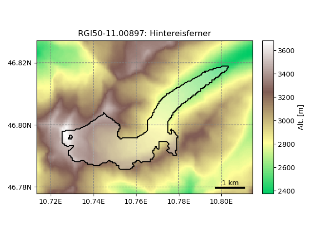
The directory is now filled with data. Other tasks can build upon these, for example the plotting functions:
In [20]: graphics.plot_domain(gdir)
What next?
This documentation is growing step by step. In the meantime, a good place
to start is the oggm/docs/notebooks directory.
You will find two notebooks:
getting_started.ipynb, which set-ups an entire OGGM run in the Ötztal region.flowline_model.ipynb, which describes the usage of the flowline model for idealized test cases.